Next Stop: Mars! Watch NASA's Perseverance Rover Attempt The Most Dangerous Landing To Date On Feb. 18
Next stop: Mars! Watch NASA's Perseverance Rover Attempt the Most Dangerous Landing to Date on Feb. 18
Tomorrow, Feb. 18, 2021, our most advanced rover named Perseverance will attempt a precision landing in Mars' Jezero Crater. Her mission is to search for signs of ancient life in the planet's geology and test technology that will pave the way for future human missions to the Moon and Mars. Excited yet? Get this:
Perseverance is ferrying 25 cameras to the Red Planet — the most ever flown in the history of deep-space exploration — so get ready to see Mars like never before! For more mission quick facts, click here.
When to watch:
Date: Feb. 18
Time: Live coverage starts at 2:15 p.m. EST (19:15 UTC)
SET A REMINDER & WATCH LIVE HERE
Want to join the #CountdownToMars? We created a virtual Mars photo booth, have sounds of Mars to listen to and more for all you Earthlings to channel your inner Martian. Check out ways to participate HERE.
If you want to follow Perseverance's journey on the Red Planet, be sure to follow her on Facebook and Twitter.
Make sure to follow us on Tumblr for your regular dose of space: http://nasa.tumblr.com
More Posts from Nasa and Others
When sending experiments to space, what is the most unexpected thing you have to think about? Like you're probably have to consider things like radiation damage, but what is something that isn't an immediately obvious issue that you have to account for?
Solar System: 5 Things To Know This Week
We live during one of the great eras of exploration. At this very moment, there are dozens of spacecraft surveying the solar system, from Mars, to Saturn, to Pluto and beyond. What’s more, you can ride along with these expeditions — all you need is an internet connection to see the latest discoveries from deep space. Here are a few essential resources for the armchair astronaut:
1. It’s Like Facebook, but for Planets

Or is it more of a Hitchhiker’s Guide to the Solar System? Whatever you want to call it, our Planets page offers quick rundowns, as well as in-depth guides, for all the major bodies in the solar system. Explore from the sun all they way out to the Oort Cloud.
2. Robots to the Rescue

Saturn looks spectacular through a telescope, but there’s only so much you can learn about it from the ground. Going there in person is tough, too. While we are now preparing to send astronauts beyond Earth orbit, a human mission to Saturn won’t be possible in the near future. That’s where the space robots come in. For example, the Cassini spacecraft studies Saturn and its moons up close, sometimes even doing things like flying right through the geyser plumes of the ice moon Enceladus. See all the solar system missions, past and present, where they went and what they’ve seen HERE.
3. Keep Your Eyes on This One

If you still haven’t tried Eyes on the Solar System, you’re missing out. This online simulation lets you tour the planets and track the past, current and future positions of spacecraft — right in your web browser, all in 3D. Eyes on the Solar System uses real NASA data to help you take a virtual flight across both space and time.
4. Images in the Raw

You don’t have to wait for a news release to see pictures from planetary missions. Some missions allow you to see raw, unprocessed images sent straight from the spacecraft. What these images lack in explanatory captions they make up for in freshness — sometimes you can see pictures from Mars or Saturn that are mere hours old. There’s something exhilarating about being among the first human beings ever to see an alien landscape. Peruse our new raw image pages HERE.
5. Bring It On Home

After you’ve toured the far reaches of the solar system, you can always come home again. When you have spent time studying the harsh conditions of our neighboring planets, the charms of a unique paradise come into sharp focus, the place we call Earth. Watch a real-time video feed from Earth orbit HERE. You can also see a daily global view of our planet from a million miles away HERE. Download THIS Earth Now mobile app to hold the planet in your hands.
Want to learn more? Read our full list of the 10 things to know this week about the solar system HERE.
Make sure to follow us on Tumblr for your regular dose of space: http://nasa.tumblr.com
A Tour of our Moon
Want to go to the Moon?
Let our Lunar Reconnaissance Orbiter take you there!

Our lunar orbiter, also known as LRO, has been collecting data on lunar topography, temperature, resources, solar radiation, and geology since it launched nine years ago. Our latest collection of this data is now in 4K resolution. This updated "Tour of the Moon" takes you on a virtual tour of our nearest neighbor in space, with new science updates from the vastly expanded data trove.
Orientale Basin

First stop, Orientale Basin located on the rim of the western nearside. It's about the size of Texas and is the best-preserved impact structure on the Moon. Topography data from LRO combined with gravity measurements from our twin GRAIL spacecraft reveal the structure below the surface and help us understand the geologic consequences of large impacts.
South-Pole and Shackleton Crater

Unlike Earth, the Moon's axis is barely tilted relative to the Sun. This means that there are craters at the poles where the sunlight never reaches, called permanently shadowed regions. As a result, the Moon's South Pole has some of the coldest measured places in the solar system. How cold? -410 degrees F.
Because these craters are so cold and dark, water that happens to find its way into them never has the opportunity to evaporate. Several of the instruments on LRO have found evidence of water ice, which you can see in the highlighted spots in this visualization.
South-Pole Aitken Basin

South Pole-Aitken Basin is the Moon's largest, deepest and oldest observed impact structure. Its diameter is about 2,200 km or 1,367 miles across and takes up 1/4 of the Moon! If there was a flat, straight road and you were driving 60 mph, it would take you about 22 hours to drive across. And the basin is so deep that nearly two Mount Everests stacked on each other would fit from the bottom of the basin to the rim. South-Pole Aitken Basin is a top choice for a landing site on the far side of the Moon.
Tycho Crater

Now let's go to the near side. Tycho Crater is 100 million years young. Yes, that's young in geologic time. The central peak of the impact crater likely formed from material that rebounded back up after being compressed in the impact, almost like a spring. Check out that boulder on top. It looks small in this image, but it could fill a baseball stadium.
Aristarchus Plateau

Also prominent on the nearside is the Aristarchus Plateau. It features a crater so bright that you could see it with your naked eye from Earth! The Aristarchus Plateau is particularly interesting to our scientists because it reveals much of the Moon's volcanic history. The region is covered in rocks from volcanic eruptions and the large river-like structure is actually a channel made from a long-ago lava flow.
Apollo 17 Landing Site
As much as we study the Moon looking for sites to visit, we also look back at places we've already been. This is because the new data that LRO is gathering helps us reinterpret the geology of familiar places, giving scientists a better understanding of the sequence of events in early lunar history.
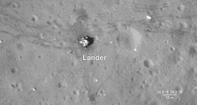
Here, we descend to the Apollo 17 landing site in the Taurus-Littrow valley, which is deeper than the Grand Canyon. The LRO camera is even able to capture a view of the bottom half of the Apollo 17 Lunar Lander, which still sits on the surface, as well as the rover vehicle. These images help preserve our accomplishment of human exploration on the Moon's surface.
North Pole

Finally, we reach the North Pole. Like the South Pole, there are areas that are in permanent shadow and others that bask in nearly perpetual light. LRO scientists have taken detailed brightness and terrain measurements of the North Pole in order to model these areas of sunlight and shadow through time. Sunlit peaks and crater rims here may be ideal locations for generating solar power for future expeditions to the Moon.
LRO was designed as a one-year mission. Now in its ninth year, the spacecraft and the data emphasize the power of long-term data collection. Thanks to its many orbits around the Moon, we have been able to expand on lunar science from the Apollo missions while paving the way for future lunar exploration. And as the mission continues to gather data, it will provide us with many more opportunities to take a tour of our Moon.
And HERE's the full “Tour of the Moon” video:
We hope you enjoyed the tour. If you'd like to explore the moon further, please visit moon.nasa.gov and moontrek.jpl.nasa.gov.
Make sure to follow @NASAMoon on Twitter for the latest lunar updates and photos.
Make sure to follow us on Tumblr for your regular dose of space: http://nasa.tumblr.com
Heads-up, Earthlings! The annual Geminid meteor shower has arrived, peaking overnight Dec. 13-14. It's a good time to bundle up! Then, go outside and let the universe blow your mind!
The Geminids are active every December, when Earth passes through a massive trail of dusty debris shed by a weird, rocky object named 3200 Phaethon. The dust and grit burn up when they run into Earth's atmosphere in a flurry of "shooting stars."
The Geminids can be seen with the naked eye under clear, dark skies over most of the world, though the best view is from the Northern Hemisphere. Observers will see fewer Geminids in the Southern Hemisphere, where the radiant doesn't climb very high over the horizon. Skywatching is easy. Just get away from bright lights and look up in any direction! Give your eyes time to adjust to the dark. Meteors appear all over the sky.
Make sure to follow us on Tumblr for your regular dose of space: http://nasa.tumblr.com.
Going for GOLD
On Jan. 25, we’re going for GOLD!
We’re launching an instrument called Global-scale Observations of the Limb and Disk, GOLD for short. It’s a new mission that will study a complicated — and not yet fully understood — region of near-Earth space, called the ionosphere.

Space is not completely empty: It’s teeming with fast-moving energized particles and electric and magnetic fields that guide their motion. At the boundary between Earth’s atmosphere and space, these particles and fields — the ionosphere — co-exist with the upper reaches of the neutral atmosphere.

That makes this a complicated place. Big events in the lower atmosphere, like hurricanes or tsunamis, can create waves that travel all the way up to that interface to space, changing the wind patterns and causing disruptions.

It’s also affected by space weather. The Sun is a dynamic star, and it releases spurts of energized particles and blasts of solar material carrying electric and magnetic fields that travel out through the solar system. Depending on their direction, these bursts have the potential to disrupt space near Earth.

This combination of factors makes it hard to predict changes in the ionosphere — and that can have a big impact. Communications signals, like radio waves and signals that make our GPS systems work, travel through this region, and sudden changes can distort them or even cut them off completely.

Low-Earth orbiting satellites — including the International Space Station — also fly through the ionosphere, so understanding how it fluctuates is important for protecting these satellites and astronauts.

GOLD is a spectrograph, an instrument that breaks light down into its component wavelengths, measuring their intensities. Breaking light up like this helps scientists see the behavior of individual chemical elements — for instance, separating the amount of oxygen versus nitrogen. GOLD sees in far ultraviolet light, a type of light that’s invisible to our eyes.

GOLD is a hosted payload. The instrument is hitching a ride aboard SES-14, a commercial communications satellite built by Airbus for SES Government Solutions, which owns and operates the satellite.
Also launching this year is the Ionospheric Connection Explorer, or ICON, which will also study the ionosphere and neutral upper atmosphere. But while GOLD will fly in geostationary orbit some 22,000 miles above the Western Hemisphere, ICON will fly just 350 miles above Earth, able to gather close up images of this region.

Together, these missions give us an unprecedented look at the ionosphere and upper atmosphere, helping us understand the very nature of how our planet interacts with space.
To learn more about this region of space and the GOLD mission, visit: nasa.gov/gold.
Make sure to follow us on Tumblr for your regular dose of space: http://nasa.tumblr.com.
Will it take pictures of Pluto?

It's Launch Day!
Final preparations are underway for today's 5:55 p.m. EDT launch of the eleventh SpaceX cargo resupply mission to the International Space Station from Launch Complex 39A at NASA’s Kennedy Space Center in Florida. The SpaceX Dragon spacecraft will liftoff into orbit atop the Falcon 9 rocket carrying about 6,000 pounds of crew supplies, equipment and scientific research to crewmembers living aboard the station. The flight will deliver investigations and facilities that study neutron stars, osteoporosis, solar panels, tools for Earth-observation, and more. Watch live coverage starting today at 5:15pm ET at http://www.nasa.gov/live
Learn more about the mission and launch at http://www.nasa.gov/spacex
Image credit: NASA/Bill Ingalls
Make sure to follow us on Tumblr for your regular dose of space: http://nasa.tumblr.com
Making the Skies Safe for Unmanned Aircraft
Unmanned Aircraft Systems (commonly known as UAS or drones) are typically a smaller aircraft that fly without an onboard pilot. Currently used for research, testing, and aerial-visual purposes, these vehicles could one day carry cargo, or even passengers, through countryside and city landscapes.

UAS are a key component of our Unmanned Aircraft Systems Integration in the National Aairspace Ssystem (UAS in the NAS) project. Our research will help develop the rules so that unmanned aircraft can safely coexist with manned aircraft in the national airspace.

We collaborate with private companies, like Navmar Applied Science Corporation (NASC), to research and test aerodynamically efficient UAS. We also work with government agencies like the Federal Aviation Administration (FAA) to conduct research that will contribute to setting standards and certifications.

We are leading the nation to open a new era in air transportation called Advanced Air Mobility (AAM). AAM will enable safe, sustainable, affordable, and accessible aviation that moves people and cargo between places using a transformed air transportation system and revolutionary new aircraft.

With new cost-and-fuel efficient aircraft and technologies becoming available, UAS will provide substantial benefit to U.S. industry and the public. Such benefits include air-lifted organ transplant deliveries that arrive more quickly and safely than ever before; and search and rescue missions performed with increased speed and accuracy.

There are other benefits too, like pizza being air- dropped to your front door, and less package delivery trucks on the road. The burgeoning landscape of AAM holds many potentials – and it’s our job to help safely and sustainably map out and navigate what that future landscape looks like.
Want to learn the many ways that NASA is with you when you fly? Visit https://www.nasa.gov/aeronautics. Make sure to follow us on Tumblr for your regular dose of space: http://nasa.tumblr.com.

Take a good look: this is the black hole at the center of our galaxy.
In the inset image, gas in the glowing orange ring surrounds the black hole's event horizon, a boundary from which nothing can escape. The ring is created by light bending in the intense gravity around Sagittarius A*, which has a mass some four million times greater than our Sun. This groundbreaking image of Sagittarius A* was taken by the Event Horizon Telescope team with data from telescopes around the world. After the EHT's iconic image of M87*, released in 2019, this is only the second time a supermassive black hole has been directly observed with its shadow.
The wider look at the space around Sagittarius A* includes data contributed by several NASA missions. The orange specks and purple tendrils were captured in infrared light by the Hubble Space Telescope, and the blue clouds represent data from our orbiting Chandra X-ray Observatory.
Fall in to the whole story: https://www.nasa.gov/mission_pages/chandra/images/sagittarius-a-nasa-telescopes-support-event-horizon-telescope-in-studying-milky-ways.html
Make sure to follow us on Tumblr for your regular dose of space!
CREDIT: X-ray: NASA/CXC/SAO; IR: NASA/HST/STScI. Inset: Radio (EHT Collaboration)
Take Your GIF Game to Cosmic Levels & React Like a NASA Astronaut!
We partnered with GIPHY to help take your GIF game to cosmic levelssss. As the Artemis generation who will witness a whole new era of space travel, we wanted make sure you could express yourself... like an astronaut!
So, if you want to show some love...

... or you’re pumped we’re half way to Friday ...

We’ve got you covered.

Don’t miss our whole collection of astronaut reactions!

Want to use them on your device?

Type ‘NASAReaction’ in your device’s GIPHY keyboard...

.... and choose your favorite!

You can access our full collection of official NASA astronaut GIFs by visiting: https://giphy.com/nasa/reaction-pack
Make sure to follow us on Tumblr for your regular dose of space: http://nasa.tumblr.com
-
 dmw10444 liked this · 2 years ago
 -
 digestiblebricks liked this · 2 years ago
 -
 cnojoy liked this · 3 years ago
 -
 suckerforkaisoo liked this · 3 years ago
 -
 artistlearningsstuff liked this · 3 years ago
 -
 annabellesacres reblogged this · 3 years ago
 -
 slowly-becoming-like-draculaura liked this · 3 years ago
 -
 eithreepi liked this · 3 years ago
 -
 catfish-908 liked this · 3 years ago
 -
 crystallineknight liked this · 3 years ago
 -
 mythbookworm18 liked this · 3 years ago
 -
 fenwyld liked this · 4 years ago
 -
 zimplelearning liked this · 4 years ago
 -
 sucrepudding liked this · 4 years ago
 -
 adobetardis liked this · 4 years ago
 -
 teachersgoglobal liked this · 4 years ago
 -
 fay-the-ghost liked this · 4 years ago
 -
 mawusifitnesstraining liked this · 4 years ago
 -
 powerfrog reblogged this · 4 years ago
 -
 edsonlima17 liked this · 4 years ago
 -
 kicsim liked this · 4 years ago
 -
 synder-sync liked this · 4 years ago
 -
 sheboyganla10boi liked this · 4 years ago
 -
 icecreamango liked this · 4 years ago
 -
bullemanrandey liked this · 4 years ago
-
 tobashii reblogged this · 4 years ago
 -
 virtualzonkslimepickle liked this · 4 years ago
 -
 h4dhero liked this · 4 years ago
 -
 drswiews-blog liked this · 4 years ago
 -
 winking-owl reblogged this · 4 years ago
 -
 dmh3000 reblogged this · 4 years ago
 -
 matthewginnow liked this · 4 years ago
 -
 creep9876-blog liked this · 4 years ago
 -
 comrade-possum liked this · 4 years ago
 -
 captain-caspian-62 liked this · 4 years ago
 -
 naturesaurus reblogged this · 4 years ago
 -
naturesaurus liked this · 4 years ago
-
 sanjogsonsand liked this · 4 years ago
 -
 granma-sweetie liked this · 4 years ago
 -
 that-enby-ash reblogged this · 4 years ago
 -
that-enby-ash liked this · 4 years ago
-
 thechandelier liked this · 4 years ago
 -
 cambridgepubliclibraryteenroom liked this · 4 years ago
 -
brentys liked this · 4 years ago
Explore the universe and discover our home planet with the official NASA Tumblr account
1K posts