Our Roman Space Telescope’s Dish Is Complete!
Our Roman Space Telescope’s Dish is Complete!

NASA engineers recently completed tests of the high-gain antenna for our Nancy Grace Roman Space Telescope. This observatory has some truly stellar plans once it launches by May 2027. Roman will help unravel the secrets of dark energy and dark matter – two invisible components that helped shape our universe and may determine its ultimate fate. The mission will also search for and image planets outside our solar system and explore all kinds of other cosmic topics.
However, it wouldn’t be able to send any of the data it will gather back to Earth without its antenna. Pictured above in a test chamber, this dish will provide the primary communication link between the Roman spacecraft and the ground. It will downlink the highest data volume of any NASA astrophysics mission so far.

The antenna reflector is made of a carbon composite material that weighs very little but will still withstand wide temperature fluctuations. It’s very hot and cold in space – Roman will experience a temperature range of minus 26 to 284 degrees Fahrenheit (minus 32 to 140 degrees Celsius)!
The dish spans 5.6 feet (1.7 meters) in diameter, standing about as tall as a refrigerator, yet only weighs 24 pounds (10.9 kilograms) – about as much as a dachshund. Its large size will help Roman send radio signals across a million miles of intervening space to Earth.
At one frequency, the dual-band antenna will receive commands and send back information about the spacecraft’s health and location. It will use another frequency to transmit a flood of data at up to 500 megabits per second to ground stations on Earth. The dish is designed to point extremely accurately at Earth, all while both Earth and the spacecraft are moving through space.

Engineers tested the antenna to make sure it will withstand the spacecraft’s launch and operate as expected in the extreme environment of space. The team also measured the antenna’s performance in a radio-frequency anechoic test chamber. Every surface in the test chamber is covered in pyramidal foam pieces that minimize interfering reflections during testing. Next, the team will attach the antenna to the articulating boom assembly, and then electrically integrate it with Roman’s Radio Frequency Communications System.
Learn more about the exciting science this mission will investigate on Twitter and Facebook.
Make sure to follow us on Tumblr for your regular dose of space!
More Posts from Nasa and Others
10 Ground-breaking Earth Satellite Images from 2018
In 2018, our satellites captured beautiful imagery from throughout the solar system and beyond. However, some of our favorite visualizations are of this very planet. While this list is by no means exhaustive, it does capture some Earth satellite images from this year that are both visually striking as well as scientifically informative. This list also represents a broad variety of Earth’s features, as well as satellite instrumentation. Take a journey with our eyes in the sky!
10. Hurricane Florence

Before making landfall, Hurricane Florence churned in the Atlantic for a full two weeks — making it among the longest-lived cyclones of the 2018 season. When it finally did hit land on Sep. 14, the storm devastated the southeastern U.S. coast with intense winds, torrential rains and severe flooding.
This natural-color image was acquired by MODIS on the Terra Satellite on Sep. 12, 2018.
Images like this, as well as other satellite information, were used to anticipate the impact of the storm. Our Disasters Program created flood proxy maps that were shared with the Federal Emergency Management Agency (FEMA) and the National Guard to estimate how many and which communities would be most affected by the storm, in order to help prepare recovery efforts ahead of time.
9. Australia’s Lake Eyre Basin

The Lake Eyre Basin covers one-sixth of Australia and is one of the world’s largest internally draining river systems. However, the rivers supported by this system are ephemeral, meaning that they only run for short periods of time following unpredictable rain — the rest of the time, the Basin is a dry, arid desert.
However, when the heavy rain comes, the basin erupts in an explosion of green. In this false-color image captured by the Operational Land Imager (OLI) on Landsat 8 on Apr. 25, 2018, you can see how the vegetation completely envelops the spaces where the water has receded. (Flood water is indicated by light blue, and vegetation is indicated by light green.)
Satellites are an excellent tool for tracking greening events that are followed by flooding. These events offer opportunities for predictive tools as well as recreation.
8. Alaska’s Chukchi Sea

A Monet painting comes to life as the Chukchi Sea swirls with microscopic marine algae.
This image was captured off the Alaskan coast by OLI on Landsat 8 on Jun. 18, 2018. After the Arctic sea ice breaks up each spring, the nutrient-rich Bering Sea water mixes with the nutrient-poor Alaskan coastal water. Each type of water brings with it a different type of phytoplankton and the surface waters have just enough light for the algae to populate and flourish. The result is these mesmerizing patterns of turquoise and green.
This image represents one piece of much larger, incredibly complex ecosystem. While one would not normally associate the breaking up of sea ice with phytoplankton blooms, it is an intricate process of the phytoplankton life cycle. The size of the blooms have varied greatly from year to year, and experts are unsure why. Images like these can help scientists track the development of these blooms and link it to other environmental changes.
7. Hawaii’s Kilauea

Sometimes fresh lava is best viewed in infrared.
This false-color image of Kilauea, captured by OLI on Landsat 8 on May 23, 2018, shows the infrared signal emitted by lava flowing toward the sea. The purple areas surrounding the glowing lava are clouds lit from below, indicating that this image was taken through a break in the clouds.
The Puʻu ʻŌʻō Kupaianaha eruption has been continuously spewing red-hot lava since 1983, making it the longest eruption at Kilauea in recorded history. However, new fissures opened up this year that forced many to evacuate the area. Hawaii’s largest lake evaporated in hours and hundreds of homes were destroyed in Vacationland and Kapoho.
Imagery, seismometers and ground-based instruments were used to track the underground movement of magma. Infrared imagery can be incredibly helpful in disasters like this when you to view data that cannot be observed with the naked eye.
6. California’s Woolsey Burn Scar

Nothing quite encapsulates the destruction of a wildfire like a photo from outer space.
This image of the Woolsey Fire aftermath in Southern California was captured on Nov. 18, 2018 by the Advanced Spaceborned Thermal Emission and Reflection Radiometer (ASTER) on the Terra satellite. This false-color infrared image has been enhanced to clearly show the burned vegetation (indicated by brown) and the vegetation that survived unscathed (indicated by green).
The Woolsey Fire clearly left its mark, with almost 152 square miles (394 square km) and 88% of the Santa Monica Mountains National Recreation Area badly burned. Images like this one can assist fire managers in the area plan for recovery.
5. Bangladesh’s Padma River

As the years go by, the Padma River grows and shrinks, twists and turns. It never has a fixed shape, and as a result, thousands of people must regularly adapt to the constant changes in the river’s 75-mile (130-km) shoreline.
This image captured on Jan. 20, 2018 by OLI on Landsat 8 depicts one of the major rivers of Bangladesh. For thirty years, scientists have been tracking the erosion of the river with satellite imagery. Combinations of shortwave infrared, near infrared, and visible light are used to detect differences year-to-year in width, depth, and shape of the river. Sometimes the river splits off, but then rejoins again later. These patterns are created by the river carrying and depositing sediment, shaping the curves of the path of water.
Monitoring the Padma River is going to become especially important as a new bridge development project advances in the Char Janajat area. Although the bridge will most certainly help shorten travel times for citizens, nobody is quite sure how the river erosion might affect the construction and vice versa.
4. Alaska’s Yakutat Glacier

It’s hard to believe that Harlequin Lake was once all dry land — but it only started to form once Yakutat Glacier started melting. The lake appeared at the beginning of the twentieth century, and has been growing rapidly ever since.
In this hauntingly beautiful image, captured on Sep. 21 2018 by OLI on Landsat 8, the effect of climate change is apparent — especially when compared to earlier images of the region.
Unless the climate warming starts to reverse very soon — which scientists consider very unlikely — Yakutat could be gone as soon as 2070.
3. South Africa’s Theewaterskloof

Cape Town is a seaside city planted on the tip of South Africa. It’s a city known for its beaches and biodiversity — it also almost became known as the first major city to officially run out of water.
This image of Cape Town’s largest reservoir — Theewaterskloof — was acquired on Jul. 9th, 2018 by OLI on Landsat 8. By the time this photo was taken, the city’s main reservoirs stood at 55%. This was a huge increase from where it stood just six months earlier: just 13%.
The severe water shortage in the region started in 2015, only to become more threatening after three successive and unusually dry years. The entire city was preparing for Day Zero — the day the tap water would be shut off.
Despite forecasts that Day Zero would arrive in April, a combination of heavier rains and local conservation efforts restored the majority of the reservoir.
2. Aerosol Earth

Aerosols are all around us. From the smoke from a fire, to the dust in the wind to the salt in sea spray — these solid particles and liquid droplets are always swirling in our atmosphere, oftentimes unseen.
The Goddard Earth Observing System Forward Processing (GEOS FP) model uses mathematical equations to model what is happening in our atmosphere. The inputs for its equations — temperature, moisture, wind, etc. — come from our satellites and ground sensors.
This visualization was compiled on Aug. 24, 2018 — obviously a busy day for aerosols in our atmosphere. Swirls of sea salt (indicated by blue) reveal typhoons Soulik and Cimaron heading straight towards South Korea and Japan. A haze of black carbon (indicated by red) suffuse from agricultural burning in Africa and large wildfires in North America. And clouds of dust (indicated by purple) float off the Sahara desert.
1. Camp Fire

With nearly a hundred fatalities, hundreds of thousands of acres burned and billions of dollars of damage, the world watched in horror as Camp Fire grew to become the most destructive California wildfire in recorded history.
This image was captured on Nov. 8, 2018 by OLI on Landsat 8 on the same day Camp Fire ignited. It consolidates both visible light and shortwave-infrared light in order to highlight the active fire. Strong winds and dry conditions literally fanned the flames and spread this wildfire like a rash.
This image has not only become the iconic portrait for Camp Fire, it is also sobering representation of how quickly a fire can grow out of control in a short amount of time. Even from space, you can almost smell the massive plumes of smoke and feel the heat of the fires.
Whether you realize it or not, our Earth satellite missions are collecting data everyday in order to monitor environmental changes and prepare for natural disasters. If your interest is piqued by this list, head over to the Earth Observatory. The Earth Observatory updates daily with fresh, new content — brought to you by none other than our eyes in the sky.
Make sure to follow us on Tumblr for your regular dose of space: http://nasa.tumblr.com
What are the moments when you think to yourself "yes. THIS is why I love my job"..? ✨
@ladyknighttime: What's your favorite activity to do in space that you might not have expected?
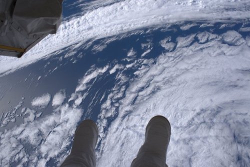
It's a long ways down. This is a view from the vantage point of astronaut Shane Kimbrough during his spacewalk last Friday outside the International Space Station. Shane posted this photo and wrote, " View of our spectacular planet (and my boots) during the #spacewalk yesterday with @Thom_astro." During the spacewalk with Kimbrough and Thomas Pesquet of ESA, which lasted just over six-and-a-half hours, the two astronauts successfully disconnected cables and electrical connections to prepare for its robotic move Sunday, March 26.
Two astronauts will venture outside the space station again this Thursday, March 30 for the second of three spacewalks. Kimbrough and Flight Engineer Peggy Whitson will begin spacewalk preparation live on NASA Television starting at 6:30 a.m. EST, with activities beginning around 8 a.m. Watch live online here.
Make sure to follow us on Tumblr for your regular dose of space: http://nasa.tumblr.com
Carbon and Our Changing Climate

Carbon is the backbone of life on Earth. We are made of carbon, we eat carbon and our civilizations are built on carbon. We need carbon, but that need is also entwined with one of the most serious problems facing us today: global climate change.
Forged in the heart of aging stars, carbon is the fourth most abundant element in the Universe. Most of Earth’s carbon – about 65,500 billion metric tons – is stored in rocks. The rest is in the ocean, atmosphere, plants, soil and fossil fuels.

Over the long term, the carbon cycle seems to maintain a balance that prevents all of Earth’s carbon from entering the atmosphere, or from being stored entirely in rocks. This balance helps keep Earth’s temperature relatively stable, like a thermostat.

Today, changes in the carbon cycle are happening because of people. We disrupt the cycle by burning fossil fuels and clearing land. Our Orbiting Carbon Observatory-2 (OCO-2) satellite is providing our first detailed, global measurements of CO2 in the atmosphere at the Earth’s surface. OCO-2 recently released its first full year of data, critical to analyzing the annual CO2 concentrations in the atmosphere.
The above animation shows carbon dioxide released from two different sources: fires and massive urban centers known as megacities. The animation covers a five day period in June 2006. The model is based on real emission data and is then set to run so that scientists can observe how greenhouse gas behaves once it has been emitted.

All of this extra carbon needs to go somewhere. So far, land plants and the ocean have taken up about 55 percent of the extra carbon people have put into the atmosphere while about 45 percent has stayed in the atmosphere. The below animation shows the average 12-month cycle of all plant life on Earth (on land and in the ocean). Eventually, the land and oceans will take up most of the extra carbon dioxide, but as much as 20 percent may remain in the atmosphere for many thousands of years.

Excess carbon in the atmosphere warms the planet and helps plants on land grow more. Excess carbon in the ocean makes the water more acidic, putting marine life in danger. Forest and other land ecosystems are also changing in response to a warmer world. Some ecosystems -- such as thawing permafrost in the Arctic and fire-prone forests -- could begin emitting more carbon than they currently absorb.
To learn more about NASA’s efforts to better understand the carbon and climate challenge, visit: http://www.nasa.gov/carbonclimate/.
Make sure to follow us on Tumblr for your regular dose of space: http://nasa.tumblr.com
Spooky Sounds from Across the Solar System
Soaring to the depths of our universe, gallant spacecraft roam the cosmos, snapping images of celestial wonders. Some spacecraft have instruments capable of capturing radio emissions. When scientists convert these to sound waves, the results are eerie to hear.
In time for Halloween, we've put together a compilation of elusive "sounds" of howling planets and whistling helium that is sure to make your skin crawl.
Listen to a few here and visit our Soundcloud for more spooky sounds.
Cassini Ring Crossing
This eerie audio represents data collected by our Cassini spacecraft, as it crossed through the gap between Saturn and its rings on April 26, 2017, during the first dive of the mission's Grand Finale. The instrument is able to record ring particles striking the spacecraft in its data. In the data from this dive, there is virtually no detectable peak in pops and cracks that represent ring particles striking the spacecraft. The lack of discernible pops and cracks indicates the region is largely free of small particles.
Voyager Tsunami Waves in Interstellar Space
Listen to this howling audio from our Voyager 1 spacecraft. Voyager 1 has experienced three "tsunami waves" in interstellar space. This kind of wave occurs as a result of a coronal mass ejection erupting from the Sun. The most recent tsunami wave that Voyager experienced began in February 2014, and may still be going. Listen to how these waves cause surrounding ionized matter to ring like a bell.
Voyager Sounds of Interstellar Space
Our Voyager 1 spacecraft captured these high-pitched, spooky sounds of interstellar space from October to November 2012 and April to May 2013.
The soundtrack reproduces the amplitude and frequency of the plasma waves as "heard" by Voyager 1. The waves detected by the instrument antennas can be simply amplified and played through a speaker. These frequencies are within the range heard by human ears.
When scientists extrapolated this line even further back in time (not shown), they deduced that Voyager 1 first encountered interstellar plasma in August 2012.
Plasma Sounds at Jupiter
Ominous sounds of plasma! Our Juno spacecraft has observed plasma wave signals from Jupiter’s ionosphere. The results in this video show an increasing plasma density as Juno descended into Jupiter’s ionosphere during its close pass by Jupiter on February 2, 2017.
Roar of Jupiter
Juno's Waves instrument recorded this supernatural sounding encounter with the bow shock over the course of about two hours on June 24, 2016. "Bow shock" is where the supersonic solar wind is heated and slowed by Jupiter's magnetosphere. It is analogous to a sonic boom on Earth. The next day, June 25, 2016, the Waves instrument witnessed the crossing of the magnetopause. "Trapped continuum radiation" refers to waves trapped in a low-density cavity in Jupiter's magnetosphere.
Visit the NASA Soundcloud for more spooky space sounds: https://soundcloud.com/nasa/sets/spookyspacesounds
Make sure to follow us on Tumblr for your regular dose of space: http://nasa.tumblr.com.
INCOMING! Roving scientist to arrive on Mars.
Save the date! One year from today, Feb. 18, 2021, our next rover is set to land on Mars. Get to know #Mars2020 now! Click here.
Make sure to follow us on Tumblr for your regular dose of space: http://nasa.tumblr.com
The Martian Movie and Our Real Journey to Mars
The Martian movie is set 20 years in the future, but here at NASA we are already developing many of the technologies that appear in the film. The movie takes the work we’re doing and extends it into fiction set in the 2030s, when NASA astronauts are regularly traveling to Mars and living on the surface. Here are a few ways The Martian movie compares to what we’re really doing on our journey to Mars:
Analog Missions

MOVIE: In the film, Astronaut Mark Watney is stranded on the Red Planet.
REALITY: In preparation for sending humans to Mars, we have completed one of the most extensive isolation missions in Hawaii, known as HI-SEAS. The goal of this study was to see how isolation and the lack of privacy in a small group affects social aspects of would-be explorers. The most recent simulation was eight months long, and the next mission is planned to last a year.
Spaceport

MOVIE: The Martian movie launches astronauts on the Aries missions from a refurbished and state of the art space center.
REALITY: Currently, the Ground Systems Development and Operations’ primary objective is to prepare the center to process and launch the next-generation vehicles and spacecraft designed to achieve our goals for space exploration. We are not only working to develop new systems, but also refurbishing and upgrading infrastructure to meet future demands.
Deep Space Propulsion

MOVIE: In the film, the astronauts depart the Red Planet using a propulsion system know as the Mars Ascent Vehicle (MAV).
REALITY: We are currently developing the most powerful rocket we’ve ever built, our Space Launch System (SLS). Once complete, this system will enable astronauts to travel deeper into the solar system than ever before! The RS-25 engines that will be used on the SLS, were previously utilized as the main engine on our space shuttles. These engines have proven their reliability and are currently being refurbished with updated and improved technology for our journey to Mars.
Mission Control

MOVIE: In the movie, Mission Control operations support the Aries 3 crew.
REALITY: On our real journey to Mars, Mission Control in Houston will support our Orion spacecraft and the crew onboard as they travel into deep space.
Habitat

MOVIE: The artificial living habitat on Mars in The Martian movie is constructed of industrial canvas and contains an array of life support systems.
REALITY: The Human Exploration Research Analog (HERA), formerly known as the Deep Space Habitat, is a three-story module that was designed and created through a series of university competitions. Studies conducted in habitat mockups will allow us to evolve this technology to create a reliable structures for use on Mars.
Rover

MOVIE: The characters in the film are able to cruise around the Red Planet inside the Mars Decent Vehicle (MDV).
REALITY: We are currently developing a next generation vehicle for space exploration. Our Mars Exploration Vehicle (MEV) is designed to be flexible depending on the destination. It will have a pressurized cabin, ability to house two astronauts for up to 14 days and will be about the size of a pickup truck.
Harvest

MOVIE: Astronaut Mark Watney grows potatoes on Mars in The Martian movie.
REALITY: We’re already growing and harvesting lettuce on the International Space Station in preparation for deep space exploration. Growing fresh food in space will provide future pioneers with a sustainable food supplement, and could also be used for recreational gardening during deep space missions.
Spacesuit

MOVIE: The spacesuit worn by astronauts in the film allows them to work and function on the surface of Mars, while protecting them from the harsh environment.
REALITY: Prototypes of our Z-2 Exploration Suit are helping to develop the technologies astronauts will use to live and work on the the Martian surface. Technology advances in this next generation spacesuit would shorten preparation time, improve safety and boost astronaut capabilities during spacewalks and surface activities.

Do you believe in magic? ✨ While appearing as a delicate and light veil draped across the sky, this @NASAHubble image reminds us of the power of imagination. What does this look like to you? In reality, it's a small section of a Cygnus supernova blast wave, located around 2,400 light-years away. The original supernova explosion blasted apart a dying star about 20 times more massive than our Sun between 10,000 and 20,000 years ago. Since then, the remnant has expanded 60 light-years from its center. Credit: @ESA/Hubble & NASA, W. Blair; acknowledgment: Leo Shatz
Falling Into Jupiter
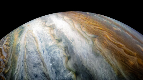
Twenty-five years ago, an object roughly the size of an oven made space history when it plunged into the clouds of Jupiter, the largest planet in our solar system. On Dec. 7, 1995, the 750-pound Galileo probe became the first probe to enter the gas giant. Traveling at a blistering speed of 106,000 miles per hour, the probe’s protective heat shield experienced temperatures as hot as the Sun’s surface generated by friction during entry. As the probe parachuted through Jupiter’s dense atmosphere, its science instruments made measurements of the planet’s chemical and physical makeup. The probe collected data for nearly an hour before its signal was lost. Its data was transmitted to Earth via the Galileo spacecraft, an orbiter that carried the probe to Jupiter and stayed within contact during the encounter. Learn more about the mission.
The Galileo probe was launched to space aboard space shuttle Atlantis in 1989

The probe consisted of a descent module and a protective deceleration module

The probe traveled to Jupiter attached to the Galileo spacecraft

The probe was released from the spacecraft in July 1995

The probe entered Jupiter’s atmosphere five months later on Dec. 7, 1995

Parachutes were deployed to slow the probe’s descent

The probe collected science data for 58 minutes as it fell into the planet’s atmosphere

The Galileo probe was managed by NASA’s Ames Research Center in California’s Silicon Valley.
Make sure to follow us on Tumblr for your regular dose of space: http://nasa.tumblr.com
-
 darkstarrydame liked this · 3 months ago
 -
 all-your-space-are-belong-to-us reblogged this · 3 months ago
 -
 in-search-of-the-peace-of-mind reblogged this · 5 months ago
 -
 supermoth-friendbug reblogged this · 9 months ago
 -
 scopophilic1997 liked this · 1 year ago
 -
 afrotumble reblogged this · 1 year ago
 -
afrotumble liked this · 1 year ago
-
 spermproducingparasiteblog reblogged this · 1 year ago
 -
 3rghost liked this · 1 year ago
 -
 itsgerges reblogged this · 1 year ago
 -
itsgerges liked this · 1 year ago
-
 ketten-krad liked this · 1 year ago
 -
 kinokochouchou liked this · 1 year ago
 -
 tethys-the-aquatic-sea-godness reblogged this · 1 year ago
 -
tethys-the-aquatic-sea-godness liked this · 1 year ago
-
 bellveder liked this · 1 year ago
 -
 venus-born liked this · 1 year ago
 -
 monirnissan liked this · 1 year ago
 -
 mad-scientist-wannabe liked this · 1 year ago
 -
 thedaylightworldofbrian liked this · 1 year ago
 -
 feeds-fort2 liked this · 1 year ago
 -
 franquikoy liked this · 1 year ago
 -
 linda69sworld liked this · 1 year ago
 -
 schenderlysil liked this · 1 year ago
 -
 unabashedmoonhideout6969 liked this · 1 year ago
 -
 mendely liked this · 1 year ago
 -
 museumofcognitiveart liked this · 1 year ago
 -
 sammyfix11 reblogged this · 1 year ago
 -
 braelynnhutton liked this · 1 year ago
 -
 haboat reblogged this · 1 year ago
 -
haboat liked this · 1 year ago
-
 drzone reblogged this · 1 year ago
 -
 generousbirdstranger liked this · 1 year ago
 -
 starchaserlovr liked this · 1 year ago
 -
 alexandriasbox reblogged this · 1 year ago
 -
 nossghoul reblogged this · 1 year ago
 -
 jezebelgoldstone reblogged this · 1 year ago
 -
 snailsarenice liked this · 1 year ago
Explore the universe and discover our home planet with the official NASA Tumblr account
1K posts